Advertisement
 20:34
20:34
Transcript
0:00
Most people around the world know the
0:02
country of Nepal for one thing, Everest,
0:05
the summit of the world. That photograph
0:08
on the poster, that bucket list
0:10
mountain, and the fact that it's used as
0:12
a superlative for anything remotely
0:14
challenging. But, despite the grandeur
0:17
of this epic mountain, it kind of steals
Advertisement
0:20
the spotlight from the rest of Nepal.
0:22
Just knowing Nepal for Everest strips it
0:25
of almost everything that makes it even
0:27
more remarkable.
0:29
Because Nepal is so much more than
0:31
Everest.
0:32
Surprisingly, it's a geographically
0:34
diverse country.
0:36
In the span of only 200 km, the land
0:38
rises from the subtropical lowlands to
Advertisement
0:41
the highest point on the planet.
0:43
That is an elevation gain of nearly 9
0:46
km. In those 200 km, you pass through
0:49
several different climate zones, from
0:52
alpine tundra to jungles, from monsoon
0:55
forest with elephants and rhinos,
0:57
through terraced hillsides and cloud
1:00
forests, and through high-altitude
1:02
grasslands and glacial valleys.
1:04
So, let's today talk about the true
1:07
geography of Nepal
1:09
in all its glory.
1:50
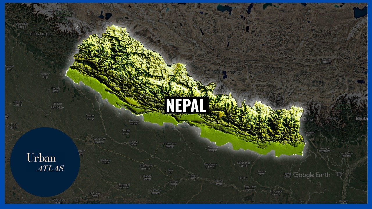
So, when we take a look at Nepal on a
1:52
map, the first thing you'll notice is
1:54
the shape, a long, narrow rectangle.
1:57
It's oriented east to west, roughly 900
2:00
km long and 200 km wide. To the south is
2:03
a long, open border with India. And to
2:06
the north is the Tibetan Plateau, the
2:08
roof of the world.
2:09
What this means is that Nepal is
2:11
landlocked, completely surrounded by
2:13
just two countries.
2:15
For a nation of over 30 million people,
2:18
this geographical reality has profound
2:20
consequences.
2:21
Most trade, most imports, and all access
2:24
to the sea must pass through India, or
2:26
to a much lesser extent, through the
2:28
long and difficult routes into China.
2:31
In terms of its size, it covers about
2:33
147,000
2:35
sq km.
2:36
About the same size as neighboring
2:38
Bangladesh. By area, it's small, but by
2:40
topographic range, it's extraordinary.
2:43
Home to eight of the world's 14 peaks
2:46
over 8,000 m, including Everest,
2:49
Kangchenjunga, Lhotse, Makalu, Cho Oyu,
2:53
Dhaulagiri, Manaslu, and Annapurna. All
2:56
epic peaks. No other country on Earth
2:59
has eight 8,000ers. Those being peaks
3:03
over 8,000 m high. But like I mentioned
3:06
previously, Nepal is a lot more than the
3:08
mountains. The Himalayas that run across
3:10
the country are just the northern third
3:12
of Nepal. The country is usually divided
3:15
into three rough horizontal zones
3:17
running east to west. The Terai lowlands
3:20
in the south, the foothills of the
3:21
Himalayas in the center, and the tall
3:24
Himalayas in the north. Each zone is a
3:26
different world, different climate,
3:28
different ecology, and different
3:30
culture. Which means to understand
3:32
Nepal, you have to understand all three.
3:35
So, let's do that, starting at the
3:37
bottom, the Terai.
3:38
Now, most people's mental image of Nepal
3:40
begins somewhere in the high hills. You
3:43
may have seen images of prayer flags
3:45
strung between peaks, or monasteries
3:47
climbing to clifftops. But the Terai
3:50
doesn't fit that image.
3:52
It's the flat southern strip of Nepal, a
3:54
narrow plain sitting between the
3:56
Himalayan foothills to the north and the
3:58
Indian border to the south. It is the
4:00
northern continuation of the great
4:02
Indo-Gangetic Plain, one of the most
4:04
fertile and densely populated
4:06
agricultural landscapes on Earth. In
4:09
Nepal, it is roughly 30 to 50 km wide
4:12
and extends the full length of the
4:13
country, east to west. Elevations in
4:16
this region are low, mostly between 60
4:18
and 300 m above sea level. The climate
4:21
is subtropical, hot summers but cool
4:23
winters, and a monsoon season from June
4:25
to September that dumps enormous
4:27
quantities of rain.
4:29
This region can feel oppressively humid
4:31
in summer with temperatures regularly
4:32
exceeding 40° C.
4:35
But this climate produces extraordinary
4:36
biological richness.
4:38
This region is home to Chitwan National
4:41
Park, one of the finest wildlife areas
4:43
in all of Asia. It protects a large
4:46
remnant of the subtropical grasslands
4:48
and riverine forest that once covered
4:50
this entire region.
4:52
Here live the one-horned rhinoceros,
4:55
a species that came perilously close to
4:57
extinction in the 20th century but has
4:59
made a remarkable recovery in Nepal's
5:01
protected areas. Also here, we find
5:03
Bengal tigers and the extremely rare
5:06
gharials, one of the strangest-looking
5:08
crocodilian species on Earth.
5:11
Sloth bears and leopards also call this
5:13
area home.
5:15
Now, surprisingly, Nepal is one of the
5:17
few countries in the world where tiger
5:18
populations are actually growing.
5:20
A census conducted in 2022 recorded over
5:23
350 wild tigers in the country, nearly
5:26
double the number of a decade earlier.
5:28
It is one of the genuine conservation
5:30
success stories of our era. This region
5:33
is also Nepal's breadbasket. Despite
5:35
covering only about 17% of the country's
5:37
land area, it produces roughly half of
5:40
Nepal's agricultural output. There's
5:42
rice, wheat, sugarcane, and lentils that
5:45
grow here in the rich alluvial soil
5:46
deposited over millennia by rivers
5:48
flowing south of the Himalayas.
5:51
This region of Nepal is home to the
5:53
Madhesi people. They make up about 30%
5:55
of the country's population and are
5:57
predominantly Hindu.
5:59
Now, the Tarai is where Nepal meets
6:01
India. And for the majority of the
6:03
population here, this is not really a
6:05
border checkpoint, but more of a porous
6:08
way of living. Many communities straddle
6:10
the border. Families are divided by it.
6:12
Languages, customs, and religious
6:14
practices flow across it. Now, let's
6:17
move north. Between the flat Tarai and
6:19
the soaring Himalayas, lies a part of
6:21
Nepal where most Nepalese have lived for
6:24
most of its history, the middle hills.
6:27
This is a zone of complex and folded
6:29
terrain. These ridges and valleys
6:32
running roughly east to west cut across
6:34
by rivers flowing south from the
6:35
mountains towards India. Elevations here
6:38
typically range from 300 m to about
6:40
3,000 m with most settlements clustered
6:43
between 1,000 and 2,500 m. High enough
6:46
to escape the Tarai's heat, but low
6:48
enough to still grow some crops. The
6:50
landscape of the middle hills is defined
6:51
above almost anything else by one
6:53
feature, terraces.
6:55
Almost every hillside in the inhabited
6:57
middle hills region has been terraced,
6:59
cut into horizontal steps to create flat
7:02
agricultural land on slopes that would
7:04
otherwise be impossible to farm.
7:06
Now, this practice of terracing in this
7:07
region has been accumulating for over
7:09
2,000 years. Generations of farmers
7:12
cutting into the hillsides, building
7:13
retaining walls of stone, channeling
7:15
water from one terrace to the next. The
7:17
result is one of the most
7:18
interesting-looking agricultural
7:20
landscapes on Earth.
7:22
Rice is the staple crop here. Where
7:24
water can be brought to irrigate the
7:25
terraces, paddy rice dominates. On drier
7:28
slopes and higher elevations, there's
7:29
millet, maize, wheat, and buckwheat. The
7:32
agricultural calendar is dictated
7:34
entirely by the monsoon here. The
7:36
arrival of the rains in June triggers
7:38
planting. The end of the monsoon in
7:39
September and October brings harvest.
7:42
Within the middle hills, one place above
7:44
all others has defined Nepali history
7:46
and culture, the Kathmandu Valley.
7:49
The Kathmandu Valley is a broad, flat
7:51
basin sitting at around 1,300 m above
7:54
sea level. Roughly oval in shape,
7:56
surrounded by hills on all sides, it is,
7:58
geologically speaking, a former lake
8:00
bed, making it extraordinarily fertile.
8:03
The Valley is home to Kathmandu,
8:05
Lalitpur, and Bhaktapur, three ancient
8:09
cities that were, until the 18th
8:10
century, three separate rival kingdoms.
8:13
The Kathmandu Valley today contains
8:16
seven UNESCO World Heritage Sites, all
8:19
within roughly 30 km of each other.
8:22
Now, the Valley's position also made it
8:23
a trade crossroads, sitting in the
8:25
middle hills between the Indian plains
8:27
and the Tibetan Plateau.
8:29
It was a natural stopping point on the
8:31
ancient trade routes carrying salt,
8:33
wool, and grain south from Tibet, and
8:35
cotton and spices north from India.
8:37
Newar merchants controlled this trade
8:39
for centuries and grew extraordinarily
8:41
wealthy. That wealth built the famous
8:44
temples in this region. Today, Kathmandu
8:46
is the capital of Nepal and home to
8:48
nearly 1.5 million people in the city
8:50
proper, and with the greater Valley
8:52
approaching 3.5 million. In its chaotic,
8:55
traffic-choked, smog-hazed, and
8:57
endlessly alive city.
8:59
The city core survives alongside what
9:02
looks like endless concrete sprawl. But,
9:05
the beauty of the city is that on clear
9:07
days, if you look to the north, the
9:09
Himalayas are right there, towering over
9:12
the city of Kathmandu.
9:15
An epic reminder that this busy,
9:17
complicated city sits at the base of the
9:19
tallest mountain system on the planet.
9:22
The middle hills are cut through by a
9:24
series of major river systems, the
9:26
Koshi, the Gandaki, and the Karnali. All
9:29
of them drain from the Himalayas
9:30
southward through the hills and into the
9:32
Terai, and then eventually the Ganges
9:34
River.
9:35
These rivers are among the most powerful
9:37
on Earth in terms of sediment load. They
9:39
carry millions of tons of eroded
9:41
mountain material downstream every year,
9:43
building the great alluvial plains of
9:45
northern India. For the people of the
9:47
hills, these rivers are both lifelines
9:50
and barriers. They provide water, fish,
9:53
and in some places hydroelectric power.
9:55
But the deep gorges they carve have
9:57
historically isolated communities from
9:59
each other. A village on one side of the
10:01
gorge might only be a kilometer from
10:03
village on the other side as the crow
10:05
flies, but hours of descent and ascent
10:08
on foot. This geographical fragmentation
10:10
has produced Nepal's extraordinary
10:12
ethnic and linguistic diversity. Over
10:14
120 languages are spoken in a country
10:17
the size of New York state. And now we
10:19
move to the Himalayas.
10:22
Now to understand the Himalayas, you
10:23
need to look at the geologic history of
10:25
this region. And for that, you need to
10:27
start about 100 million years ago. That
10:30
time, what is now the Indian
10:31
subcontinent was not attached to Asia at
10:33
all. It was an island, a vast northward
10:36
drifting landmass.
10:38
Over tens of millions of years, the
10:40
Indian subcontinent drifted north. Then,
10:43
around 50 million years ago, India
10:45
collided with Asia. The seafloor
10:47
sediments that had accumulated in it
10:49
were compressed and crumpled upwards.
10:51
And the collision, which actually is
10:53
still ongoing, began building the
10:55
Himalayas. The Indian plate is still
10:57
pushing north. The Himalayas are still
10:59
rising about 5 mm per year. Nepal sits
11:03
directly on this collision zone. The
11:05
ground beneath Kathmandu is being
11:07
compressed, uplifted, and periodically
11:09
shattered by earthquakes that release
11:10
the accumulated stress of two continents
11:12
grinding against each other. And this is
11:15
exactly what caused the 2015 Gorkha
11:18
earthquake in Nepal. It was magnitude
11:20
7.8, and it killed nearly 9,000 people,
11:24
destroyed hundreds of thousands of
11:25
homes, and triggered avalanches on
11:27
Everest that killed climbers at base
11:29
camp. It was a reminder, brutal and
11:32
sudden, that Nepal does not sit on
11:34
stable ground. It sits on one of the
11:36
most geologically active zones on the
11:38
planet.
11:39
And here is something that you might
11:40
find interesting. On the summit of Mount
11:43
Everest is limestone, marine limestone
11:46
full of fossils of tiny sea creatures,
11:48
meaning the highest point on Earth
11:51
was actually at the bottom of a tropical
11:53
sea 450 million years ago. Tectonic
11:56
forces lifted it nearly 9 km. But
11:59
Everest is just but one mountain. Nepal
12:02
is home to eight of the world's 14 peaks
12:05
above 8,000 m. Each one is distinct in
12:08
its character, in its difficulty, and in
12:10
the history of human attempts on it.
12:13
There is Annapurna in the west of Nepal.
12:15
It was the first 8,000er ever summited
12:18
by French climbers Maurice Herzog and
12:21
Louis Lachenal. It was the first
12:23
mountain above 8,000 m that any human
12:25
being had ever stood on. And it remains,
12:27
statistically, the most dangerous of all
12:30
the 8,000ers. Its death rate is among
12:33
the highest of any major Himalayan peak.
12:35
Nearby is Dhaulagiri, also in western
12:38
Nepal. It rises so dramatically from the
12:41
surrounding terrain that early European
12:43
surveyors briefly considered it as the
12:44
highest mountain in the world. While far
12:47
to the east of Nepal sits Kangchenjunga,
12:50
the third highest mountain in the world
12:52
at 8,586
12:54
m. It is worshipped as a sacred deity by
12:57
the Sikkimese people. And by tradition,
12:59
climbers stop a few meters short of the
13:01
actual summit out of respect, a
13:03
remarkable act of restraint at the edge
13:06
of one of humanity's greatest physical
13:08
challenges.
13:09
But the Himalayas are not uninhabited.
13:12
People have lived in these mountains for
13:14
thousands of years, and their
13:15
adaptations to extreme altitude are
13:17
among the most remarkable in human
13:19
biology. These Sherpa people, who
13:21
predominantly reside in the Khumbu and
13:23
the Solo regions of Nepal, migrated from
13:26
eastern Tibet roughly 500 years ago and
13:28
settled in the high valleys of Northeast
13:30
Nepal. They are famous worldwide for
13:32
their role in Himalayan mountaineering,
13:34
but their geographical significance goes
13:36
far beyond guiding expeditions. They
13:39
developed a civilization at elevations
13:41
that would debilitate most humans.
13:43
Sherpa communities have been in this
13:45
environment long enough to develop
13:46
genetic adaptations to altitude,
13:49
including a variant of the EPAS1 gene
13:52
that allows their bodies to use oxygen
13:54
more efficiently at low partial
13:55
pressures. Above the settlements, the
13:57
landscape becomes one of the most severe
13:59
on Earth. The high Himalayan valleys and
14:02
passes are home to glaciers, thousands
14:04
of them,
14:05
covering an estimated 5,000 square
14:07
kilometers of Nepal. And these glaciers
14:09
are the source of the rivers that
14:11
sustain hundreds of millions of people
14:13
downstream in Nepal, India, Bangladesh,
14:16
and Pakistan. The Himalayan glacier
14:18
system is sometimes called the third
14:20
pole after Antarctica and the Arctic.
14:23
Now, let's leave behind the high peaks
14:25
of the Himalayas and talk a little bit
14:27
about Nepal's climate. And you cannot
14:30
talk about Nepal's climate without
14:32
mentioning the monsoon. The South Asian
14:34
monsoon is one of the most powerful
14:36
atmospheric systems on Earth. It is
14:38
driven by the differential heating
14:40
between the Indian Ocean and the Asian
14:42
landmass. In summer, the land heats
14:44
faster than the ocean,
14:46
causing the air over the Indian
14:48
subcontinent to rise. This causes moist
14:51
air from the Indian Ocean to take its
14:53
place. When the air hits the Himalayas,
14:55
the greatest topographic barrier on
14:57
Earth, it's forced upward. It cools and
15:00
releases its moisture as rainfall,
15:02
enormous, torrential, and possibly
15:04
months-long rainfall.
15:06
The monsoon typically arrives in Nepal
15:08
in June and lasts through September. And
15:11
in that 4-month window, roughly 80% of
15:13
Nepal's annual precipitation falls.
15:16
Rivers that were quiet mountain streams
15:17
become raging torrents. Terraced
15:20
hillsides green up almost overnight. But
15:22
the monsoon is not uniform across Nepal.
15:26
The middle hills and the Terai region
15:28
receive more than 2,000 mm of rain
15:30
annually, and over 80% of that is during
15:33
the monsoon. However, the complex
15:35
topography of the middle hills region
15:37
means that there's a lot of local
15:39
variation. But the rain shadow effect
15:41
behind the Himalayas is dramatic. The
15:44
high valleys of northern Nepal,
15:45
sheltered by the main Himalayan range,
15:48
receive only a fraction of the monsoon
15:50
rainfall. Places like Mustang and Dolpo,
15:53
upper valleys tucked behind the
15:54
mountains, receive an almost central
15:56
Asian dryness, receiving less than 200
15:59
mm of rain per year.
16:01
And this dry, arid region is home to one
16:04
of Nepal's most extraordinary places.
16:07
This is Lo Manthang, the walled city of
16:10
Upper Mustang. It sits in a desert at
16:12
3,840
16:14
m. Its mud-brick architecture and
16:16
Tibetan Buddhist culture feel entirely
16:18
different from the rest of Nepal.
16:21
The monsoon also defines Nepal's
16:23
economy. Agriculture, still the primary
16:25
livelihood for the majority of Nepalese,
16:28
depends entirely on monsoon timing and
16:30
intensity. A late monsoon or a weak one
16:33
means poor harvests and food insecurity.
16:36
A particularly violent monsoon could
16:38
mean flooding, landslides, and the loss
16:40
of everything a family has built. Nepal
16:43
sits almost exactly at the point where
16:45
the monsoon hits the Himalayas hardest,
16:47
which means the stakes of every year's
16:49
rains can be enormous.
16:52
Now that we've explored the physical
16:53
geography of Nepal, let's talk about the
16:56
cities of Nepal. What are they like, and
16:58
where are they located? We already spoke
17:00
a little bit about Kathmandu, but what
17:03
other large cities are in Nepal?
17:05
Well, Nepal's second largest city is
17:07
Pokhara. It sits in a broad valley like
17:10
Kathmandu at around 820 m above sea
17:12
level. It's lower and warmer than
17:14
Kathmandu, and its defining feature is
17:17
probably Fewa Lake, a large blue-green
17:20
lake whose southern shore has become the
17:22
spine of Nepal's tourism industry
17:24
outside of the Everest region. To the
17:26
north of Pokhara lies the Annapurna
17:28
Massif, which rises to over 8,000 m. So,
17:32
just imagine on a clear morning standing
17:35
at the lakeside of Fewa Lake, looking to
17:37
your north and you see the massive
17:39
Annapurna. And because of this
17:41
proximity, Pokhara is actually the
17:43
gateway to the Annapurna Circuit and the
17:45
Annapurna Sanctuary, two of the world's
17:48
most celebrated trekking routes.
17:50
Hundreds of thousands of trekkers pass
17:51
through this city each year, either
17:53
setting out into the hills or returning
17:55
from them. But Pokhara is not just a
17:58
gateway for Annapurna. It's an actual
18:00
city with over 600,000 people, and it
18:02
has a different character than the
18:04
larger Kathmandu. Less congested,
18:07
greener, and significantly wetter.
18:09
Pokhara receives more rainfall than
18:11
almost anywhere else in Nepal. And the
18:13
result of this are lush hills, full
18:16
rivers, and dramatic waterfalls.
18:18
Beyond Kathmandu and Pokhara, there are
18:20
other cities, particularly in the Terai
18:23
region near the Indian border. Here lies
18:26
Biratnagar, home to jute mills, sugar
18:28
factories, and a growing manufacturing
18:30
sector. There is also Birgunj, the main
18:33
gateway for goods crossing from India
18:35
into Nepal. Now, this city processes an
18:38
enormous proportion of the country's
18:39
imports and has grown into a substantial
18:42
commercial city entirely on the back of
18:44
its border position. But Nepal's cities
18:46
are not yet dominant in the way the
18:48
cities of India and China or Southeast
18:50
Asia are. But the trajectory is clear.
18:53
Nepal is urbanizing faster than most
18:56
people realize. And the cities being
18:58
built now, how they are planned, and how
19:00
they manage their growth will shape much
19:02
of Nepal's future.
19:04
So, we started this video talking about
19:06
a mountain, or rather, the reduction of
19:08
an entire country to a single iconic
19:11
peak. But, like I said, Nepal cannot be
19:14
defined by just one mountain. It is so
19:18
much more than that. It is a country and
19:20
a land that compresses much of Earth's
19:22
environments into a small region.
19:25
From tropical lowlands to the Earth's
19:27
highest peaks, it tells the story of a
19:30
collision between continents still
19:32
unfolding underneath this beautiful
19:33
country.
19:35
It tells the story of people who learned
19:37
to live in a place that most people
19:39
would not even survive in.
19:42
Its resourceful people terraced
19:43
impossibly steep slopes and built cities
19:46
on ancient lakebeds. Despite being
19:48
landlocked, earthquake-prone, and
19:50
dependent on monsoon rains, the people
19:53
of this country carved out their unique
19:55
culture. So, let's not just limit Nepal
19:58
to Everest or the Himalayas. It is so
20:01
much more than that, and I hope this
20:03
video helped you realize that.
20:05
And as always, if you'd like content
20:06
like this, give this video a like.
20:08
Subscribe to the channel if you haven't
20:09
done so already, and let me know in the
20:11
comments below if you want me to
20:12
continue making videos about different
20:14
countries and their geography.
20:17
And thank you to each and every one of
20:19
you who's followed me over the past year
20:20
and a half.
20:22
I've now passed 100,000 subscribers, and
20:24
when I first started this channel, I had
20:26
no idea that I'd be getting here.
20:28
So, thank you to each and every one of
20:30
you.
20:31
And I'll catch you in the next one.
20:33
Peace.
— end of transcript —
Advertisement